______________________________________________________
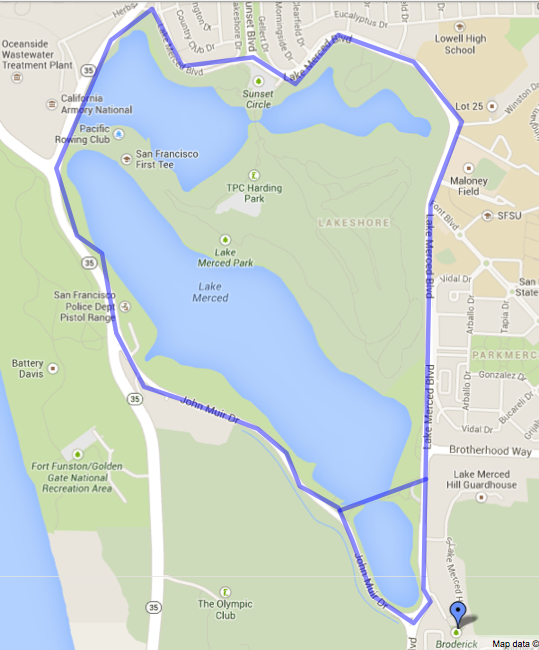 |
| The Lake Merced Loop at 4.2 or 4.5 miles |
Distance: 4.2 - 4.5 miles
Elevation: <100 feet
Difficulty: Easy to moderate
Time: 1.5 - 2 hours
Dog Friendly: Yes, on leash
Hike Description
Lake Merced is located in the Lakeshore neighborhood in the southwestern corner of San Francisco.
The Lake Merced loop is not the most scenic hike in San Francisco, nor it is the most peaceful. Despite these negatives, what I like about this hike is that it carries a certain sense of accomplishment with it. It’s a good enough distance that you’re going to be walking for an hour to an hour and a half, and you get to circle an entire natural lake and bird habitat.
Much of this route is flanked with busy roads - namely Lake Merced Boulevard, John Muir Drive, and Skyline Drive, so expect to hear some level of buzz from the cars whizzing by. As you walk around the lake, you will see housing developments, golf courses, and schools. Unfortunately, much of the paved trail surrounding the lake is block off from the lake thick trees and a tall fence. To get a closer look at the lake, I recommend taking a small shortcut that takes the walk from 4.5 miles to around 4.2 miles. To take this shortcut, you’ll go on the Lake Merced Concrete Bridge just south of Brotherhood Way. Here, you can see the natural beauty of Lake Merced. You’ll see ducks swimming, people fishing, and families picnicking.
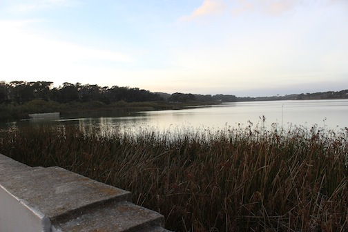 |
| Finally, a lake view! |
Route Details
As
the hike is a straightforward loop, you have the convenience of being
able to start it anywhere. There are numerous parking lots and two bus
lines that serve the area, so get off where you please and start
walking. While many people run this route, feel free to walk, take your
time, and sit on a bench or two.
Getting there
- Public Transit: MUNI Bus #18 allows you to access the western side of the lake
- MUNI Bus #29 takes you to the northern parts of the lake near the canoe and boat rental areas.
- For MUNI bus information, call 311. Outside San Francisco, call (415) 701-2311.
- Parking: There are numerous parking lots near Lake Merced. These include:
- Lake Merced and Sunset Blvd*
- Lake Merced and Brotherhood Way
- Lake Merced and South State Dr
- Skyline Blvd and Harding Rd**
* This is where I normally start my hike
**This entrance has restrooms and picnic tables.
Lake Merced History
Lake Merced is the largest of the seven remaining natural lakes in San Francisco. At one point as little as 3,000 years ago, the lake was a brackish lagoon that connected to the Pacific Ocean. Over time however, sand accumulations closed off the channel to the Ocean, and Lake Merced became a freshwater lake.
Like many other areas of San Francisco, Lake Merced was originally inhabited by the Ohlone Indians. When the Spanish arrived in San Francisco in 1776, they came across Lake Merced while looking for a place to build the Presidio, their military fort. Lake Merced’s name derives from the Spanish “La Laguna de Nuestra Señora de la Merced,” or The Lake of Our Lady of Mercy.
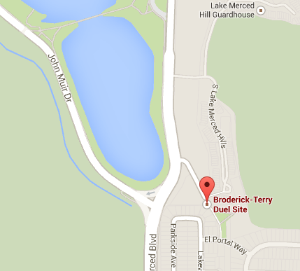 In September 1859, the lake served as a backdrop for a duel between David Broderick, a US Senator and David S. Terry, ex-Chief Justice of the Supreme Court of California. Both Broderick and Terry were Democrats, however, Broderick was an abolitionist while Terry was pro-slavery. The two men had previously been friends, but the relationship soured when Terry accused Broderick of having had a role in his failed 1859 re-election campaign . Terry, on his end, retaliated by issuing inflammatory comments at a convention in Sacramento. To resolve their differences, the two agreed on a duel. Terry won the coin toss to choose weapons, and he selected pistols that had hair triggers. Broderick's first shot discharged early, and he was left open to Terry's shot. Terry hit the senator and he died three days later. Today, you can visit the Broderick/Terry duel site near the southeast portion of the lake. If you want to visit the duel site, the closest intersection is El Portal Way and Lakeview Drive.
In more recent history, San Francisco Recreation and Parks acquired the 740 acres of parkland around and including the lake in 1950. Today, the area is popular for walkers, runners, cyclists, fishing enthusiasts, and golfers (the lake is flanked by three courses: Harding Municipal Golf Course, Olympic Country Club, and San Francisco Golf Club). Much to the chagrin of local fishermen, the golf courses’ irrigation needs have been drying out the lake. In 1994, the lake reached an all time low of 14 feet in depth.
Recently, California Trout, a nonprofit organization dedicated to preserving trout, steelhead, salmon and their environment, has intervened to try and save the lake. The Lake Merced Task Force and the Friends of Lake Merced have also come together to join the cause. Water levels are up and water and fish conditions continue to improve.
Happy trails!
This comment has been removed by a blog administrator.
ReplyDelete