
Concrete Mixer Upper - Sidewalk Mistakes Cast in Stone

The beauty of the Internet age is that we have the power to undo almost everything we create. With the simple click of the delete button, our mistakes are erased and forgotten.

Unfortunately, not everything today is part of the Internet age, and the evidence of this is all over our city streets. 

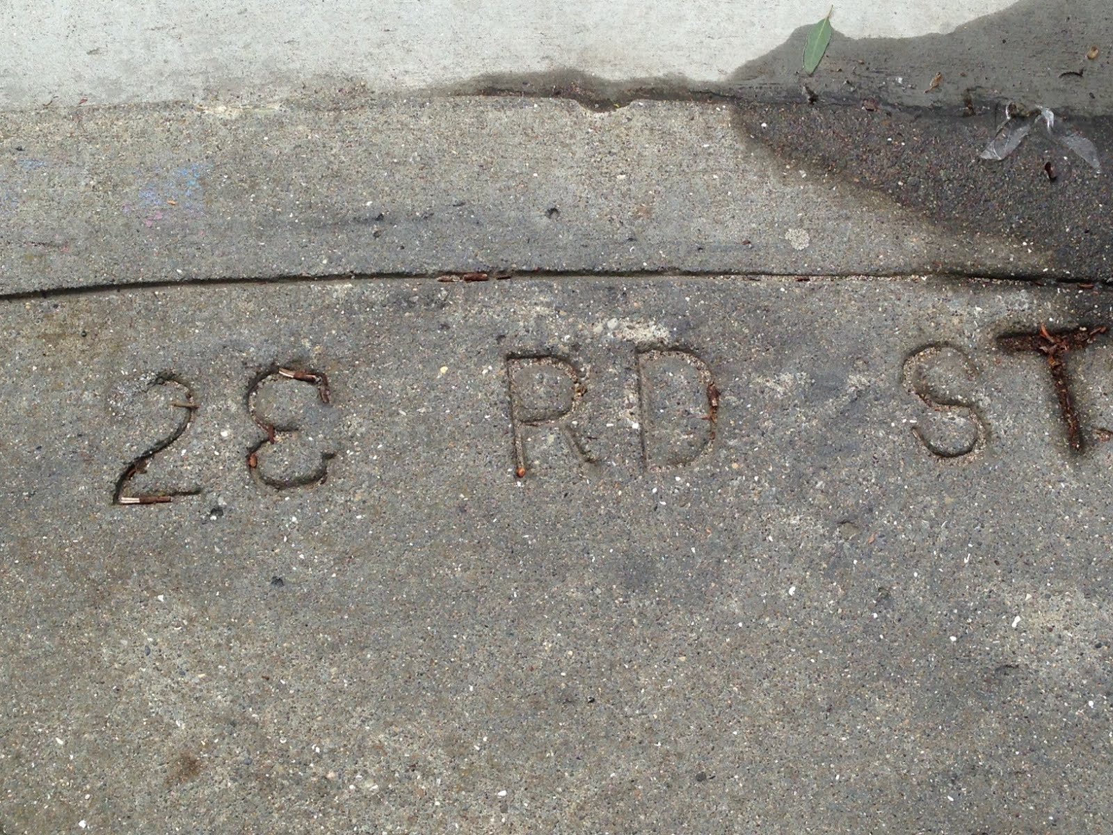
In case you haven’t noticed, you’ll find the name of the street stamped into the concrete at most San Francisco street corners. The DPW contracts the stamping job to a third party, and while they get it right most of the time, there have been some laughable typos cast into the concrete.  

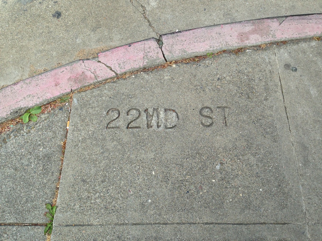
One of the first sidewalk typos I remember seeing was on 22nd and Church. On the southeast corner of the street, I found “22 ND” stamped with a backward N. Just one block later, I found 23RD with a backwards and upside down “3”. Since spotting those, I’ve been scouring the sidewalks for typos, and I’ve found a number of gems.


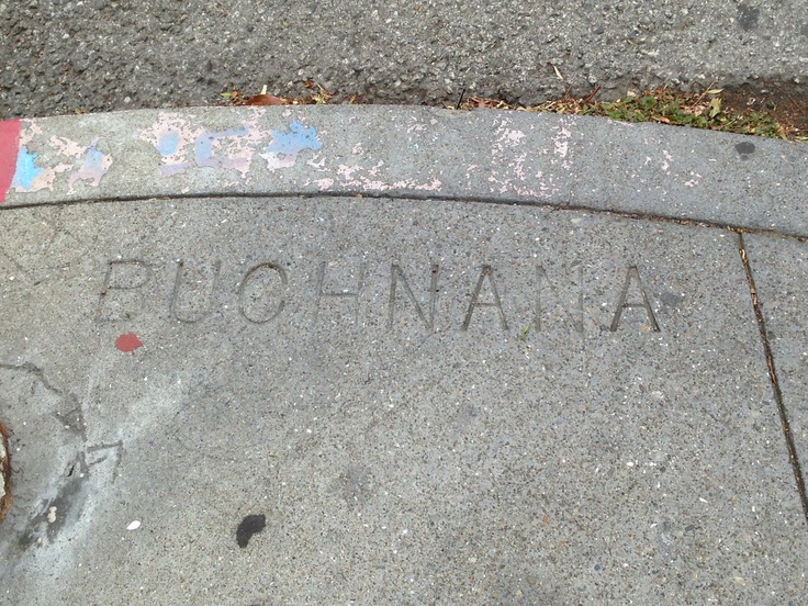
There was “Buchnana” where Buchanan was supposed to be. There have also been the two-typo stamps where “Sacarmneto” was written instead of “Sacramento”. The typos are scattered throughout the city and come in a few varieties (mixed up letters, missing letters, numbers replacing letters (1 for I is a common one).


I’ve started collecting typos in a Pinterest board here, and have found a photoset on flickr that has over one thousand typos. I would love to see all the concrete mixer uppers you’ve found. Email me at info@urbanhikersf.com if you find other ones not yet on my radar.

Comments

  1. This comment has been removed by a blog administrator.

    ReplyDelete
  2. This comment has been removed by a blog administrator.

    ReplyDelete
  3. This comment has been removed by a blog administrator.

    ReplyDelete

Post a Comment

Popular posts from this blog

The San Francisco Roundabout Trail - An urban hike fueled by determination, grit, and pain meds

On October 5, 2025, five of us met before dawn at the corner of John Muir Drive and Sklyine Boulevard. Our goal: Complete the new 38-mile Roundabout Trail . To walk the route in one day, we’d have to keep our bodies moving for over half a day with minimal stops, witnessing the sunrise, the full day, and the sunset. I’d walked up to 34 miles in a day on the NYC Shorewalkers Great Saunter , but 38-miles was terra incognita for me. Internalizing my learnings from the Great Saunter, I popped some “vitamin I” — or ibuprofen before we even started walking.   Stats:  Distance: 41.67 miles — 3 miles longer than predicted. Every extra step hurt. Steps: 81k steps — and I felt every single step beyond 60k. Time: 14 hours on the dot (6:30 am - 8:30 pm including all stops). Company: Started with 5, picked up 4 en route, and ended with 4   The Roundabout Trail is broken into five sections, and we decided to start somewhere in the middle of section 4 w...

Hike all of SF Post 6: Lake Merced Loop

I'm on a mission to #hikeallofsf . These are the stories of my hikes. _______________ ______________________________ _________ The Lake Merced Loop at 4.2 or 4.5 miles Hike Name: Lake Merced Loop Distance: 4.2 - 4.5 miles Elevation: <100 feet Difficulty: Easy to moderate Time: 1.5 - 2 hours Dog Friendly: Yes, on leash Hike Description Lake Merced is located in the Lakeshore neighborhood in the southwestern corner of San Francisco. The Lake Merced loop is not the most scenic hike in San Francisco, nor it is the most peaceful. Despite these negatives, what I like about this hike is that it carries a certain sense of accomplishment with it. It’s a good enough distance that you’re going to be walking for an hour to an hour and a half, and you get to circle an entire natural lake and bird habitat. Much of this route is flanked with busy roads - namely Lake Merced Boulevard, John Muir Drive, and Skyline Drive, so expect to hear some leve...

Two Great Hikes Near Cavallo Point and Fort Baker

Links and images refreshed 7/30/2025   Last year, I went to a wedding reception at the Cavallo Point Lodge and my boyfriend and I decided to spend the night there. The morning after the reception, we wanted to take advantage of our location and get some exercise, so we decided to explore some local trails. I revisited these trails again recently and wanted to write about them so you can take advantage of them, too.     Hike 1: Cavallo Point Loop 2.0 miles, 260 feet elevation gain Strava route to download or duplicate     From outside the hotel’s main building (where the valet stand is) walk diagonally across the large lawn to reach the intersection of Murray Circle and Center Road. There you'll see a (small) trail sign for the Bay Trail. Head straight here onto Moore Road and then take your first left onto Sommerville Street. Start walking along Horseshoe Bay.  When you reach the Presidio Yacht Club after about 0.1 mile, take a ...