I'm on a mission to #hikeallofsf. These are the stories of my hikes.
______________________________________________________
In 1999, the parties agreed to make the Greenway a reality, and in 2000, construction began. The Greenway’s major goals included educating people about natural sciences, nutrition, and plants; creating open recreational space; and making the neighborhood more pedestrian-friendly.

Hike Statistics
- Distance: 0.5 miles one way
- Elevation: 150 feet
- Difficulty: Easy
- Time: <1 hour
- Dog Friendly: No
Introduction to The Visitacion Valley Greenway
In 1995, Fran Martin and Anne Seeman had a vision for transforming Visitacion Valley, a working-class neighborhood that had developed a reputation for drugs and crime. The women worked with the Trust for Public Land to gain rights to empty lots in the neighborhood from the San Francisco Public Utilities Commission and the San Francisco Recreation and Park Department.
The women’s vision was the Visitacion Valley Greenway, a checkerboard of six adjacent one-block-long parks: Hans Schiller Plaza, a community garden, an herb garden, a children’s playground, an agriculture garden, and a native plant garden.
The women’s vision was the Visitacion Valley Greenway, a checkerboard of six adjacent one-block-long parks: Hans Schiller Plaza, a community garden, an herb garden, a children’s playground, an agriculture garden, and a native plant garden.
In 1999, the parties agreed to make the Greenway a reality, and in 2000, construction began. The Greenway’s major goals included educating people about natural sciences, nutrition, and plants; creating open recreational space; and making the neighborhood more pedestrian-friendly.
As you meander through the parks, you will notice some common themes: terra-cotta-colored walkways, black gates, and mosaic art. Additionally, the parks were all designed with accessibility in mind, which means that wheelchair users can enjoy the Greenway, too.
In 2004, the Greenway was turned over to the San Francisco Recreation and Park Department. It has become a success, revitalizing the community and providing nearly two acres of green space for a diverse wildlife community.
Route Details
Route Details
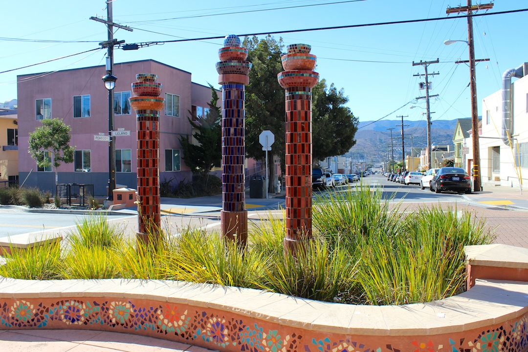
You will find the entrance to the Greenway on Leland Avenue between Rutland Street and Alpha Street. Whimsical mosaic columns and a low mosaic wall welcome you into Hans Schiller Park. More columns greet you as you enter the park and find the colored walkway that will take you through the six sections of the Greenway.
After exiting Hans Schiller Park, cross Raymond Avenue and look for the familiar black gates across the street.
You are now in the community garden, which features multiple gardening plots and two greenhouses. Here the walkway hugs the left side of the park while the garden occupies the right three-quarters of the park.
 After the community garden, you will cross Arleta Avenue to enter the herb garden, which houses terraced beds, lavender-lined pathways, and outdoor education spaces with seating and picnic areas. Make sure to look back every now and again to catch a glimpse of San Bruno Mountain behind you.
After you leave the herb garden and cross Teddy Avenue, your fourth park is the children’s play garden, which is equipped with a small playground and a playfully-decorated front gate.
Once you exit the play garden, cross Campbell Avenue to reach the agriculture garden where you will encounter seasonal crops and fruit trees, which were planted to teach the community about nutrition.
To reach the last park, the native plant garden, cross Tucker Avenue. Here the walkway zigzags left and right for 200 feet, reaching an incline of 40 feet. The garden is a habitat for local wildlife such as bees, butterflies, other insects, and birds.
At the end of the native plant garden, you will be on Tioga Street and will have reached the end of the Greenway.
Continuing on to McLaren Park
After exiting Hans Schiller Park, cross Raymond Avenue and look for the familiar black gates across the street.
You are now in the community garden, which features multiple gardening plots and two greenhouses. Here the walkway hugs the left side of the park while the garden occupies the right three-quarters of the park.
After the community garden, you will cross Arleta Avenue to enter the herb garden, which houses terraced beds, lavender-lined pathways, and outdoor education spaces with seating and picnic areas. Make sure to look back every now and again to catch a glimpse of San Bruno Mountain behind you. After you leave the herb garden and cross Teddy Avenue, your fourth park is the children’s play garden, which is equipped with a small playground and a playfully-decorated front gate.
Once you exit the play garden, cross Campbell Avenue to reach the agriculture garden where you will encounter seasonal crops and fruit trees, which were planted to teach the community about nutrition.
To reach the last park, the native plant garden, cross Tucker Avenue. Here the walkway zigzags left and right for 200 feet, reaching an incline of 40 feet. The garden is a habitat for local wildlife such as bees, butterflies, other insects, and birds.
At the end of the native plant garden, you will be on Tioga Street and will have reached the end of the Greenway.
Continuing on to McLaren Park
McLaren Park is just a short walk from the Visitacion Valley Greenway. To get to the park, follow Tioga Avenue west one-half block east to Delta Street. Then, walk one block north to take Delta Street back to Wilde Avenue. Make a last left on Wilde Avenue to reach this street’s intersection with Ervine Street. From here, you can use the stairway or a trail to climb a steep 300 feet to reach the park entrance. From here, you can do the Philosopher’s Way hike (see pages 40-43) or take your own route around the park.
Getting there
Getting there
Public Transit: MUNI bus 9 will take you to Bayshore Boulevard and Arleta Avenue. Walk south two blocks on Bayshore to reach Leland Avenue. Then take Leland Avenue past Alpha Street (Alpha will be the first street on your right) to find the entrance to the Greenway. If you reach Rutland Street, you have gone too far. For MUNI bus information, call 311. Outside San Francisco, call (415) 701-2311.
Parking: There is metered parking along Leland Avenue. There is plentiful, unmetered parking along Raymond Street and other streets around the Greenway.
Visitacion Valley History
Visitacion Valley History
Visitacion Valley’s modern history began on July 2, 1777, when Spanish priests first saw the area on their way to the Presidio. They found the land where the neighborhood now stands when they lost their way in the fog. The priests said their first mass there on the feast of the Visitation, an event that gave the neighborhood its name. For many years after that, the land was used to graze cattle.
Then in 1822, Mexico gained its independence from Spain, and in 1841, Visitacion Valley became part of a land grant, Rancho Cañada de Guadalupe la Visitación y Rodeo Viejo that also contained today’s McLaren Park.
The first landowners in the area were Irish and Italian factory workers. Windmills also irrigated a number of farms in the area, giving the neighborhood its former nickname, “Valley of the Windmills.” In the 1870s, Visitacion Valley was home to a ribbon factory, breweries, quarries, a fertilizer company, and the Southern Pacific Railroad.
Starting in 1925 (and until 1999), Schlage Lock was a major presence. And during World War II, the nearby Hunters Point Naval Shipyard employed a large number of African Americans, which led to an influx of working-class blacks into the area. While African Americans still comprise 30 percent of the neighborhood population, over half of Visitacion Valley’s residents are now Chinese.
Comments
Post a Comment