Whether you're a tourist, an SF noob, or an old-timer (like I'm becoming 😱), we all want the same thing: killer photos of the Golden Gate Bridge 🌉. After 13 years in this city (and 8 of them guiding folks around on hiking tours and writing hiking books), I've identified some special spots for memorable shots. This post covers 10 spots in San Francisco, and soon I'll post on where to take bridge photos in Marin County.
Ten San Francisco spots to take great photos of the Golden Gate Bridge

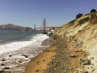
Baker Beach
Location: Battery Chamberlin Road in the Presidio
About: The combo of the bridge, beach, and ocean make Baker Beach a classic choice for Golden Gate Bridge photos. The only issue you can run into here is that it can get crowded on warm days. To ditch the crowds, head north, but if you're shy, don't roam too far as the north end of the beach is known for its nude sunbathers.
Parking: LARGE parking lot (rare for SF!) at the end of Battery Chamberlin Road.

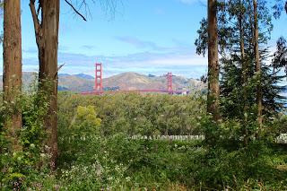
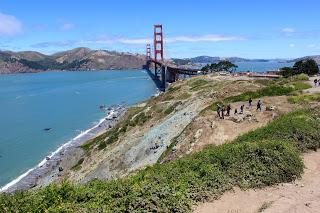
Location: Lincoln Boulevard in the Presidio
About: I literally wrote the book on hiking in San Francisco, and in my opinion, this is the most scenic 0.7-mile stretch of trail in the entire city. If you can handle the 500 or so stairs, you’ll rack up countless bridge views on your way. See the next entry for another special spot along this trail.
Parking: Park near the Immigrant Point Overlook to start at the south end of the trail or in the Langdon Court parking lot to start at the north end of the trail.
Fun fact: This is where I shot Urban Trails: San Francisco’s cover photo.
Marshall's Beach
Location: Off the Batteries to Bluffs Trail in the Presidio.
About: Marshall's Beach can only be accessed from the Batteries to Bluffs Trail. Given its remote location, it’s often empty! To get this shot, make sure you don't miss the turnoff: look for a sign 0.3 miles from either end of Batteries to Bluffs.
Parking: Same parking areas as Batteries to Bluffs.
San Francisco National Cemetery Overlook
Location: Off Nauman Road in the Presidio
About: The San Francisco National Cemetery Overlook provides a poignant setting for bridge photos and there are rarely more than a few people here at a time. From Nauman Road, follow the paved path into the woods. When the path splits, stay right. Keep following the paved trail and after a minute or two, you'll end up at a viewing area with benches. Walk in front of the benches to get this view.
Parking: Nauman Road (enter 474 Nauman Road into Google Maps.)
Crissy Field
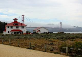
Location: Crissy Field
About: It doesn't get much more classic SF than Crissy Field. Walk as far as you want to get as close to the bridge as you want! Take beachy shots, marshy shots, or shots with buildings. There is no way to mess this up. Continue to Fort Point (see below) to get views of the bridge’s arch.
Parking: Start as far east as the Crissy Beach parking lot or as far west as the Hamilton Street parking area.
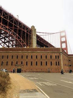
Fort Point National Historic Site
Location: Fort Point
About: Built between 1853-1861, Fort Point predates the Golden Gate Bridge by multiple decades. When the bridge was being designed, there was talk of tearing down the military installation, but instead, a new plan was hatched...just redesign the bridge! If you wanted to know why there's an arch on one side of the bridge and not the other, it’s to accommodate Fort Point. Come here for military history and views of the first tower and arch. This is just beyond Crissy Field if you want to start or end your photoshoot there.
Parking: Marine Drive. See Fort Point on Google Maps.
Coastal Trail Gun Batteries
Location: California Coastal Trail leading up to the bridge. Look for Battery Godfrey, Boutelle, and Marcus Miller on Google Maps.
About: Visit old (never used) gun installations along the Pacific Coast with nonstop bridge views. Climb on top of the batteries to get unobstructed bridge views or take photos of the bridge with the batteries in the frame.
Parking: Park in the Langdon Court parking lot and head north!

Battery East Picnic Area
Location: Battery East Trail just west of the tunnel
About: This special spot is sandwiched between two places called “Golden Gate Postcard Viewpoint” and “Viewpoint Golden Gate Bridge” on Google Maps. That said, those places can be crowded and everyone has those shots. I really love this spot as it’s crowded with tourists. On the Battery East Trail, look for the pedestrian tunnel (see location above). Make sure you’re on the west side of that tunnel. Walk behind the picnic benches and take this shot!
Parking: Battery East parking lot.

Location: Lincoln Boulevard between Washington Blvd and Battery Dynamite Rd.
About: The Pacific Overlook was added to the Presidio in 2012. Here, you’ll get views spanning from Lands End to the bridge—and you’ll also get views of the Marin Headlands across the Ocean. There are benches here so take your time with these views.
Parking: WWII Memorial parking lot or the Langdon Court parking lot.

The San Francisco Bay
Location: Multiple spots around SF
About: If you want to take unique photos of the bridge, head into the bay for a boat cruise. I personally love riding with Adventure Cat. You’ll even go under the bridge for some seriously striking views.
Parking: Adventure Cat's tours depart from Pier 39.
Comments
Post a Comment