My Corona Quest: Documenting all of San Francisco's ~1000 public stairways.

In mid-March 2020, the coronavirus began spreading rapidly across the United States, and here in San Francisco we were the first city in the country to go into lockdown. We were supposed to stay at home and only go out for the essentials, such as food and exercise, but as per usual I was antsy AF. 🤣

I wanted to follow Mayor Breed's stay at home order, so I decided I would go out, but I would only go as far as my legs would take me (no cars, buses, or Lyfts). After a few walks throughout the Mission, Castro, Glen Park, Diamond Heights, and Potrero Hill, I was reminded of all of the amazing stairways scattered throughout the city.

Auspiciously, I had also checked out Stairway Walks in San Francisco from the library. I thought to myself, "What if I could see them all?" I then had the idea to document all of San Francisco's stairways.

Over the past five months, I have documented 800 stairways on a map (https://bit.ly/sfstairmap), a spreadsheet (https://bit.ly/sfstairsheet), and photos (which you can find both the map and spreadsheet. It's a work in progress and I have 100-200 more stairways left to document.

Traveling through all of San Francisco's neighborhoods has given me a new appreciation for San Francisco. I hope you'll check out my map, spreadsheet, and photos and share in my joy in exploring the city.
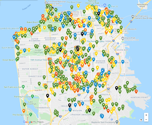
Google map with pins representing every stairway in San Francisco

A glimpse at the SF Stair Map

 
In case you are interested in learning more about the project, here are some questions you might have about it.

Vallejo between Montgomery & Kearny

How should I use your spreadsheet and map? 


Here’s my recommendation: Start by choosing a neighborhood you want to explore. Some great stairway neighborhoods are Telegraph Hill, Russian Hill, Dolores Heights, Bernal Heights, Forest Hill, and Golden Gate Heights. Then look on the map and identify some stairways you might want to see. You can decide which stairways to visit based on their "rating" (see below) or by looking at the photos when available. Make a route that connects the stairways you want to see and start climbing!
 
Why stairways?  
When I moved to San Francisco, my dad got me a copy of the book Stairway Walks in San Francisco (then by Adah Bakalinsky, now by Mary Burk and Adah Bakalinsky). Having lived in non-stairway-filled cities before moving to SF, I thought stairways seemed to be an interesting, signature aspect of this particular city. So I started noticing them, exploring them, and taking photos of them. 
 
How did you become an expert in stairways? 
I have done lots of city exploring on my own in my 13 years in San Francisco. I also run a hiking company called Urban Hiker SF and have written a book on hiking in San Francisco called Urban Trails: San Francisco. I have dedicated about 8 years of my life to exploring the city’s outdoor spaces. That said, there may be people here who know much more than I do!

Tell me about the rating scale you use.
I used the rating scale from Burk & Bakalinsky’s book as a starting point
(see spreadsheet for more details on the rating system) and then used my best guess to rate the stairways I added to the list. I also updated some of the ratings in the book if I didn’t agree with them. As with all types of ratings, these stairway ratings are very subjective. I’m not trying to upset anyone whose favorite stairway doesn’t have a very high rating. You can make a copy of the spreadsheet and make your own rating system!
 
Did you take all of the photos and visit all of the stairways?
Yes, I took all the photos beside the few that have photo credits attached to them. I have been to 95%  or so of the stairways with photos on the map and in the spreadsheet. There are just a few I haven’t been to in Golden Gate Park.

Bengal Alley near Mount Davidson
What are your favorite stairways?

Of course, I love the mosaic stairways as they bring life and color into neighborhoods across the city. I also like some impressive, but lesser known ones like Bengal Alley near Mount Davidson or a stairway in Bernal Heights squeezed between two buildings that feels like you’ve discovered a city secret.  
 
How many public stairways do you think there are?

My best guess is over 1,000.
 
What do you count as a stairway?
For the purpose of this project, I’m looking at public stairways that anyone can use at any time. A stairway is intended as a stairway—so decorative steps that don’t go anywhere don’t count. If something has at least 2-3 steps though, it counts! Don’t worry though, most of the steps on the map and the spreadsheet have much more than 2-3 steps.
 
I know a stairway you don't know about
I bet you do! My map and spreadsheet are hopefully a good starting point for most stairway explorers. If you know of a stairway I should know about, email me at info@urbanhikersf.com and I’ll get it added to my list.
 
Normandie Terrace in Pacific Heights
Do you have a stairway map for the East Bay?

No I don’t. The Berkeley Path Wanderers have a great East Bay map of stairways and paths and you could read Secret
Stairs East Bay
. If you’re just looking to hike in the East Bay, I have a book for that! It’s called Urban Trails: East Bay.
 
What's next?
Well, I still have over 200 stairways to check out, so that should keep me busy for a while. After this is done, I’m thinking I’d like to create a resource (like an ebook) featuring the 50-100 “best” stairways in the city that would include photos, history, and more.

Where can I get more updates on you and this project?

Instagram: @urbanhikersf
Twitter: @urbanhikersf 
Or join our mailing list - head to www.urbanhikersf.com and look for the signup link at the bottom of the page.

You can also email me directly at alexandra@urbanhikersf.com with comments or questions!

Comments

Popular posts from this blog

Four Quick Steps For Identifying Poison Oak

It's that time of year again, and poison oak leaves are sprouting out all over the Bay Area. Getting poison oak is no fun, so if you don't know what poison oak looks like, today is your day to learn!   Poi son oak, you say... So first, why is poison oak so poisonous? It's not that it's actually poisonous, but it does contain urushiol , an oil that can irritate the skin, causing rashes or blisters. The frustrating thing about poison oak (well, one of many frustrating things) is that it's hard to know immediately if you've had contact with the plant. It normally takes 24-36 hours for any skin irritation to appear. I have a quick four-step system to identify poison oak. Feel free to check it out and let me know what you think. (Remember, I am not a medical professional. This is not medical advice. :)) The four-step system Step 1: Listen to the old adage, "Leaves of three, let it be." Poison oak has clusters of three leaves on the entire plan...

Two Great Hikes Near Cavallo Point and Fort Baker

L ast year, I went to a wedding reception at the Cavallo Point Lodge and my boyfriend and I decided to spend the night there. The morning after the reception, we wanted to take advantage of our location and get some exercise, so we decided to explore some local trails. I revisited these trails again recently and wanted to write about them so you can take advantage of them, too. Hike 1: Cavallo Point Loop 
1.9 miles, 300 feet elevation gain Shortened version on the trail on Relive     Strava route to download or duplicate From outside the hotel’s main building (where the valet stand is) walk diagonally across the large lawn to reach the intersection of Murray Circle and Center Road. There you'll see a (small) trail sign for the Bay Trail. Head straight here onto Moore Road and then take your first left onto Sommerville Street. Start walking along Horseshoe Bay.  When you reach the Presidio Yacht Club after about 0.1 mile, take a wood walkway in front of ...

Hike all of SF Post 6: Lake Merced Loop

I'm on a mission to #hikeallofsf . These are the stories of my hikes. _______________ ______________________________ _________ The Lake Merced Loop at 4.2 or 4.5 miles Hike Name: Lake Merced Loop Distance: 4.2 - 4.5 miles Elevation: <100 feet Difficulty: Easy to moderate Time: 1.5 - 2 hours Dog Friendly: Yes, on leash Hike Description Lake Merced is located in the Lakeshore neighborhood in the southwestern corner of San Francisco. The Lake Merced loop is not the most scenic hike in San Francisco, nor it is the most peaceful. Despite these negatives, what I like about this hike is that it carries a certain sense of accomplishment with it. It’s a good enough distance that you’re going to be walking for an hour to an hour and a half, and you get to circle an entire natural lake and bird habitat. Much of this route is flanked with busy roads - namely Lake Merced Boulevard, John Muir Drive, and Skyline Drive, so expect to hear some leve...